Augmented Reality for Utilities – Is It Industry Ready?
Darius Mirdamadi | 22 November 2021


In the last few years, you may have heard people talking more and more about Augmented Reality (AR) as a tool for visualisation of asset data in the real world. But is it ready for the utilities industry, and is the industry ready for it?
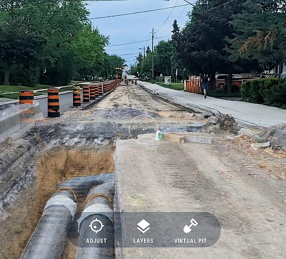
AR allows the user to ‘augment’ 3D georeferenced digital versions of anything (including utility assets) and render it in ‘reality’ through a device camera. This technology is available now on the phone in your pocket via applications such as vGIS.
How does AR work?
AR apps on AR-supported devices* make use of the device’s camera to build up a 3D model of the world around you using ‘surfaces’ such as the ground or buildings. 3D digital objects can be superimposed on this real-world view as seen through the camera. This 3D ‘digital twin’ could be sewer mains, lamp posts, or building plans. In fact, it could be anything as long as it has a real-world position. The device uses constant camera feedback combined with the device location to provide your relative position to the 3D object. This projects the illusion that the object is there by your side or under your feet!
The hard graft is performed by the device processor which is constantly crunching a barrage of mathematical calculations provided by the camera, the GPS location, and the data source itself. Corrections for object drift are also applied on the fly to mitigate incorrect movement interpretation caused by other moving ‘surfaces’ such as cars.
AR at its best…
At its best, AR provides users with accurate and stable in-field visualization of underground pipes, cables, and other utility objects with X-ray-like vision. This improves situational awareness, which improves workforce productivity by letting field crews perform common tasks faster and easier. Using GPS the user is always placed accurately relative to field assets and therefore negates the need for cumbersome paper plans. Higher awareness also reduces accidents by revealing hidden hazards and asset dependencies.
Reality capture is another tool that is being added as a capability to some AR apps. Reality capture allows you to use your device to capture your surroundings and configure this as a layer in your AR view. This can be extremely useful for recording and visualising previous stages of a construction build for example. The capture can work in a couple of different ways. Images can be captured from the device camera and stitched together and georeferenced in a process called photogrammetry. Alternatively, more recent devices such as the latest iteration of iPhone/iPad can use its internal LiDAR capabilities to build and overlay a point cloud model of your surroundings in real-time! It really is mind-blowing what can be achieved. Reality Capture can provide a wonderfully vivid mixed reality experience.
And at its worst…
At its worst, AR can be slow and jerky leaving the user confused and disorientated by what they are viewing. The failure in these scenarios to blend asset data with reality can ultimately lead to a mistrust of the technology and applications being discarded, but it needn’t be that way!
Getting the best AR experience
To achieve the best AR experience a number of factors have to be considered:
- Device Type – You need a relatively new iOS or Android device to provide the best experience for the reasons described above. Battery life should be a big consideration as AR apps can be very power hungry. For this reason, plus screen size, tablets tend to perform better.
- Positional Accuracy – Although the internal phone/tablet location provider can be used, high accuracy plugin devices such as the eos Arrow or Leica FLX100 are recommended with AR apps. Using the internal antenna provided can cause inaccuracies especially when your 3D assets cover a large area. High accuracy GNSS will constantly correct your position in rea-time meaning very high 3D object stability.
- Spatial Data Quality – None of the above factors will matter if your data is of poor spatial quality. If, for example, a manhole has been recorded 1 metre away from its true position then you could have the most powerful phone on the market paired with a 1cm accurate GNSS receiver. Your assets will still not be positioned correctly in AR. Of course, this positional accuracy needs to be correct in three dimensions!
Conclusions
Augmented Reality has enormous potential to improve on-site spatial awareness and the rate applications such as vGIS are developing is phenomenal. AR is often held aloft as the ‘holy grail’ for site awareness.
Choosing hardware wisely is extremely important to providing the best on-site experience. However, critical to being ‘AR ready’ is bringing accurate spatial data to the table. Poor data in equals Poor data out!
MGISS are world leaders in this regard for shaping our customer’s journey from location to insight. With the help of our partners Esri UK and Eos Positioning Systems by providing world-leading asset location and asset capture solutions. Bring all this together and you can unlock the ultimate in-site asset insight.
*Devices must support ARCore for Android or ARKit for iOS.
About
With degrees in Geological Sciences and Geographical Information Systems, Darius has significant expertise and knowledge of Geospatial tech integration, specialising in high-accuracy mobile GIS deployment. Darius is the technical lead for IPAS and supports other large GIS-centric contracts in the utilities sector. Combining GIS development skills and years of customer insight he was able to create some of our leading solutions Z-Transform and DDMS for Highways.


