Mapping a future sustainable reality
Mike Darracott | 31 January 2022

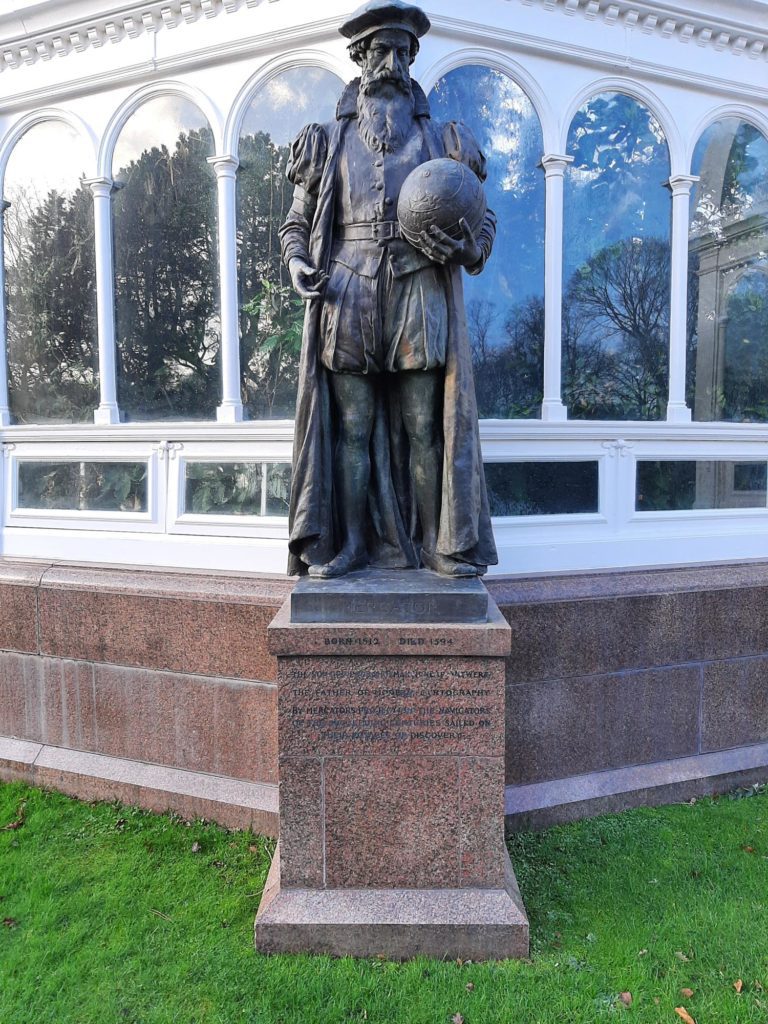
I have been trying to take in more of my local surroundings of late, and while walking in the local park came across a statue of Gerardus Mercator, who is possibly the most famous cartographer in history, mainly due to the worldwide use of his Mercator Projection, or “world map” as most would know it. Our perceived view of the world dates back to 1569 when this was published, and it is the map that we all remember from school.

I was also then reminded of a scene in the US Political drama The West Wing when, due to its popularity, those who watched became caught up in a realisation that the Mercator projection was not all it was thought to be… https://youtu.be/vVX-PrBRtTY
The ensuing confusion by these senior US politicians is tangible, with my favourite line being “nothing is where you think it is!”
Now, for many who work with maps it will be quite well known that the Mercator Projection is biased towards those early shipping navigation routes, in that the central part of the projection is more accurate than the top and bottom – in essence, the errors are pushed to the edges…
The point of this – maps are so important to allow us to know where things are – but the truth is distorted to give a best fit when working on a larger scale such as the whole world. There are lots of other projections available, but many would argue that because so much convention is based on Mercator that we shouldn’t change it.
Thankfully in the UK as in many other countries, more accurate maps have been created to base information and decision-making on, although it needs to be understood that errors still get “pushed” to the edges or map boundaries. A good example of this is with Ordnance Survey maps, created historically using traditional surveying methods and at different scales to map larger areas such as rural and moorland areas. This means that as cities have expanded and maps have been used as a reference for recording where things such as buildings, roads and the services that run above and below, there will be errors between where we think things are, and where they actually are.
As more and more maps become available, digital transformation and technology allows us to capture information more accurately, there is a need to update existing location data – where we historically think things are – to improve our knowledge of where things actually are. This allows better insight and decision-making, but even more importantly, it allows the smooth running of our communities, cities and connections in between to work more effectively and sustainable.
Mercator was a pioneer, as are all those scientists, engineers and professions throughout the ages who have strived to create a better knowledge of the earth and enable us all to know where things are and how to live better lives.
We need to collectively appreciate the past, but also learn from the example and errors of the past to better inform what we do today.
Todays engineers and surveyors capturing or updating records have a duty to do it well, and adopt technology that provides improved location to ensure better future decision-making. Those responsible for our infrastructure have a duty to provide the investment in data maintenance, and those who regulate and govern have a duty to enforce it.
Of course it isn’t as simple as that – but it should be. Albert Einstein once said that “Reality is merely an Illusion, albeit a persistent one.”
I am a great believer in persistence, and also believe we all have a duty to create a better reality for future generations.
About
Michael founded MGISS in 2014 to combine his extensive experience in the utility and infrastructure sectors, with a desire to transform the way these industries think about the value of spatial data and sustainability. As a qualified Engineering Surveyor, Michael has worked across engineering, national mapping agencies, commercial technology providers and in surveying and design since 1995, and sees his role as “building bridges” between people, technology and sustainability as an aid to solving global challenges.


