Why trust maps?
Mike Cooper | 25 August 2021


Somewhere between lies and truth lies the truth.
This was the headline at the entrance to Damien Hirst’s, Treasures of the wreck of the Unbelievable exhibition in Venice. A hoard of art works that had ‘supposedly’ been recovered from the ancient wreck of a vast ship, the ‘Unbelievable’.
The impressive collection of Aulus Calidius Amotan, a freed slave better known as Cif Amotan II, which was destined for a temple dedicated to the sun.
It was a lie of course but listening in there were several visitors who were ready to accept the idea that the statue of the artist with Mickey Mouse, covered in porcelain barnacles and corals, was indeed recovered from the wreck sunken some 2,000 years ago.
This led me to think about what lies beneath the data truth, intrigued by our all accepting trust in digital mapping and GNSS, given the ever-increasing number of incidents where someone, blindly following their Sat Nav, manages to drive off a cliff.
Our increasing reliance on machines and more importantly our trust in data and GNSS technology appears to be a growing issue with potentially catastrophic implications, placing responsibility on those who deliver data content to ensure the accuracy and reliability of the information that is placed in the hands of others
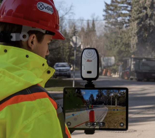
With the growth of Virtual Reality applications, I am regularly approached by field workers demonstrating that they can now see the cables and pipelines hidden below the ground they are standing on as though it’s absolute undisputable fact. It’s a great opportunity to ask about the provenance, accuracy and currency of the data being used to provide the visual insight as to what is hidden beneath the ground before they start digging.
Investing in asset data
Investing in asset data as a corporate data asset requires a disciplined approach, supported by structures, processes and people with the understanding and knowledge to capture, maintain and use this valuable resource.
It’s essential that all involved in the process of managing and utilising asset information, truly understand how the data will be used to ensure that it remains fit for purpose.
The ultimate goal, of delivering a single, fully maintained, authoritative and accurate digital version of the asset data truth, thanks to advances in GIS and GNSS technology is now possible.
Once the value and beneficial outcomes are fully understood, it just takes organisational commitment for the immediate benefits to become apparent – improved productivity, efficiency, safety and more importantly; continuity of service and supply with access to asset data insights that can anticipate and avoid service interruptions.
By ensuring I can easily interrogate the asset data with the attribution that tells me when it was captured, how it was captured and importantly to what accuracy it was captured at, means that I’m standing here, confident that what lies beneath, is indeed, the asset data truth.
Mike Cooper, Strategy and Innovation Manager at MGISS To enquire about asset data quality improvement, contact us.
About
Mike has spent over 45 years in the surveying and Geospatial industries in both technical and commercial roles, across the UK and internationally. Mike is focused on developing MGISS as a leading geospatial services provider, creating collaborative and innovative partnerships to further grow the business in its core markets.


