Our location 53.38538, -2.97972
Our location 53.38538, -2.97972
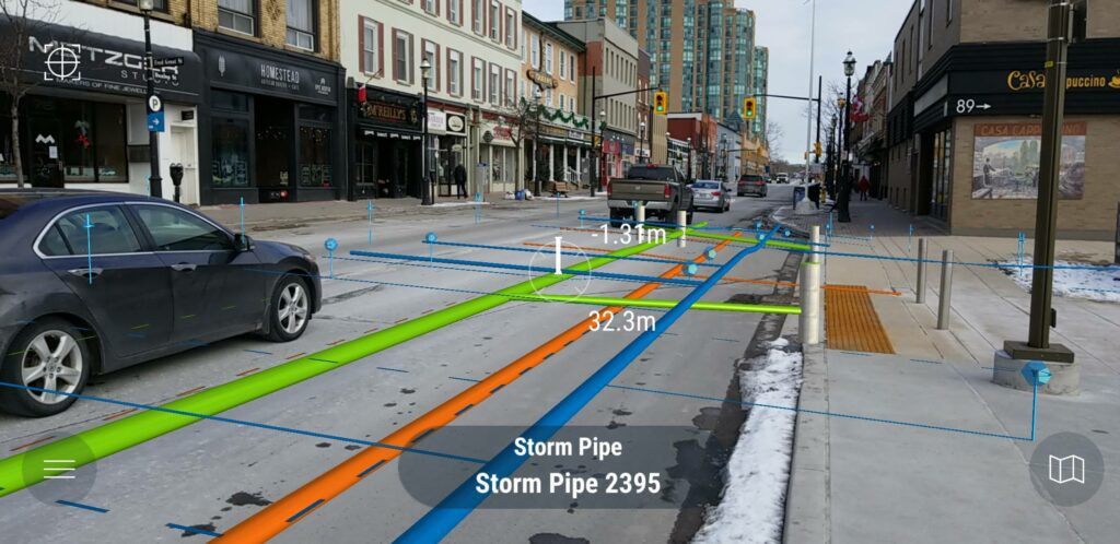
Help improve your teams situational awareness with a solution that is an efficient platform and mobile app – vGIS utilising augmented reality technology. vGIS helps reduce strikes by 30% by leveraging your data correctly, whilst providing both peace of mind and engineering accuracy to those working onsite, in real-time, before they break ground and during any dig.
Our visualisation solution reduces the average time to locate assets by 50% whilst simultaneously increasing validation time by 66-85%.
Unlocks productivity gains of 10% immediately with the potential to reduce time-spent locating an asset by up to 20-hours.
Operatives, Engineers, and Supervisors working on sites across the UK are at a huge disadvantage when they use traditional site plans as they often struggle to visualise the reality of what and where assets lie underground. This can lead to costly re-work, delays, and dangerous strike accidents.
In the UK, there are approximately 4 million excavations undertaken each year, with 60 thousand strikes on buried service pipes and cables, this has an economic cost of £1.2bn.
Our solution combines a variety of fit-for-purpose data and augmented reality to visually identify the precise location of sub-surface assets, on any site, scheme, and programme. We take data, designs, and drawings and put them in the hands of everyone on site. This ensures situational awareness of their surroundings and the assets underneath them, empowering your team to make safer decisions when they dig.
Using augmented reality in the vGIS mobile app and platform, make highly accurate real-time decisions on excavation locations, including busy and exposed roadside locations.
3D data capture of otherwise hidden assets helps support the productivity and safety goals of mobile operations and field teams, a vital element when working to tight deadlines.
By leveraging your BIM, CAD, and GIS data, vGIS helps you drive productivity and safety whilst improving cross-team working and unlocking value in your office to field procedures.