
Testimonial
"They’re really key to us because the geospatial industry is so fast moving, and we’ve got to keep on top of it, and to do that we need experts around in times of business need."
Our location 53.38538, -2.97972
Our range of high-accuracy data capture solutions can be taken on location to record accurate, richly attributed asset data. Once asset data is captured, you can enable the continuous improvement of asset data quality. With this accurate and high-quality data, you will be able to gain influential insights with MGISS Asset Insight services.
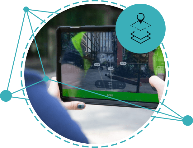
With our high-accuracy data capture solutions, you can improve your customer experience, sales performance, and operational efficiency by utilising the power of geospatial data. Gain situational intelligence on assets using geolocation data in-house, and incorporate advanced location-based use cases, across multiple business areas and end-customer journeys.
You need reliable data collection and capture solutions to acquire highly accurate geospatial data. Our GNSS receivers help collect cm-level accurate data, enabling your team to improve operational efficiency, make smarter decisions, and increase productivity.
Whilst we’re an independent provider of solutions, MGISS are an authorised UK distributor for Leica Zeno and Eos Arrow Series Controllers, and we’re an Esri Silver partner. We pride ourselves on our relationship with our partners, united in a common goal – to deliver invaluable geospatial insights to the end-user.

MGISS supports Utility companies with Enterprise grade GNSS, 1cm high-accuracy RTK positioning services, fully integrated software solutions, and unparalleled support from our team of geospatial experts.
We can design, source, build, test, and deploy solutions from our partner network.
All of our solutions are compatible with PAS256 as-built, and NUAR requirements.

We support Infrastructure companies with highly ruggedised Enterprise grade GNSS, 1cm high-accuracy RTK positioning services, fully integrated software solutions, and support from our expert GIS team.
We can design, source, build, test, and deploy solutions from our partner network.
All of our solutions are compatible with high-accuracy PAS128, PAS256, NUAR, CS551, and CD535 specifications.

MGISS provides Environment companies with highly ruggedised professional grade GNSS receivers, local and global correction services, fully integrated software solutions, and support from our trusted GIS team.
We can design, source, build, test, and deploy solutions from our partner network.
All our solutions are highly portable and compliant with International and British standards such as BS5837.
Global Navigation Satellite Systems is the general term for satellite systems that provide navigation, positioning and timing services.
To understand and or record your current position on the earths surface and relative position to other real world objects. high accuracy receivers can provide this position to around 1cm precision.
GIS and geospatial data are used interchangeably but the two terms refer to different things, read our article to learn more
Having an accurate real-world position of your assets can be beneficial for many reasons from accurate flow modelling to re-location of buried services.
The main difference is that the Arrow Gold has a separate receiver and cabled antenna whereas the GG04 has the antenna and receiver in the same housing. The trade-off is that due to reduced antenna interference the Arrow Gold tends to have superior performance in poor conditions i.e. under tree canopy.
Yes, however it is more likely that accuracy will be compromised under tree canopy due to deflected satellite signals.
Hundreds of free to use basemaps are available to both including StreetMap and Aerial imagery types.
ArcGIS Online is a cloud-based Geographic Information System (GIS) allowing users to capture, store, manage and share geospatial datasets.
Make sure your ArcGIS feature layer is Z-enabled on creation. Altitude will then always be captured along with the 2D global position. To capture accurate height values for the UK see the MGISS Z-Transform plugin for ArcGIS Field Maps.
Yes, the frequency’s transmitted by GNSS satellites were chosen, in part, to be minimally affected by water vapor in the atmosphere. Only solid objects will affect the signal strength, meaning for example, GNSS won’t work inside buildings.
The Arrow Gold has been designed to be used in all weather conditions. It is waterproof and its Ingress Protection rating is IP67.
Currently, only the FLX100+ works with iOS mobile or tablet devices. The FLX100 is compatible with only Windows and Android Devices, whereas the FLX100+ is compatible with iOS, Windows and Android.
Yes the Arrow Gold works with not just ArcGIS Field Maps, but all ESRI Field Data Capture apps (ArcGIS Survey123, ArcGIS Quick Capture and ArcGIS Sweet).
Yes we can accommodate hires for GNSS equipment.


