Watchers in The Sky
Darius Mirdamadi | 4 April 2022


Look upon a clear night and you may be lucky enough to witness a bright star-like object tracking across the sky. Is it a meteor shower? A plane? A UFO? The most likely explanation is you are watching the orbit of one of the 7,900 human-made satellites ranging from 180km to more than 35,000km about the Earth’s surface. This number confirmed in September 2021 by the United Nations Outer Space Objects Index is astounding, it really is turning into a bumper-to-bumper highway up there!
The first-ever satellite (Sputnik) was launched by the Russians in 1957 then roughly 60 to 100 satellites were launched yearly until the early 2010s and since then a very dramatic increase. Supriya Chakrabarti (prof of physics at the University of Massachusetts) writes that in 2020, 114 launches carried around 1,300 satellites into space, however for 2021, by September roughly 1400 new satellites began their Earth orbits. The vast majority of these were smallsats (weighing less than 600kg). The dramatic recent size reduction of satellites makes it so much easier to launch them, partly explaining the rapid increase, but what are all these satellites for?
What are they all for?
Satellites perform a vital role in Earth observation, space observation, navigation, and communications and provide humanity with many tools and services that we rely on today. In terms of daily tangible impact on our lives then anything from weather reports to using a sat-nav system to tracking your Uber driver or even using a modern ATM would not be possible without the services provided by satellites.
At a more existential level satellites are helping us to answer some of the most fundamental questions about the course of humanity and the impact of climate change. Remote sensing and atmospheric observations carried out by satellites have brought the issues of climate change into sharp focus. Satellites can track changing weather patterns and changing land use such as the destruction of rainforests, the retreat of Earth’s glaciers, and rising sea levels. Images such as the one below showing retreating glaciers from the mountains of Indonesia have put humanity on high alert.
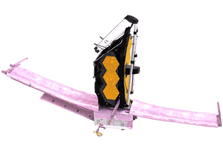
By looking inwards, we have been attempting to map out Earth’s future, and by pointing our satellites outwards we can look deep into the past. Tracking the most distant and ancient galaxies of our universe allows us to ‘time-travel’ and answer the ultimate questions about the origins of the universe. The most recent example is the James Webb telescope launched on Christmas Day 2021. Technically this will be parked 1 million miles from earth and will be a satellite of the sun. The James Webb telescope will essentially be a replacement for Hubble and allow us to peer deeper into the universe and therefore further back in time than ever before!
Asset Locate and Asset Capture
Did you know we can now record and locate our assets on the ground with pinpoint accuracy using GNSS (Global Navigation Satellite System)? GNSS is the name given to the various navigation satellite constellations such as GPS (United States), GLONASS (Russian), BeiDOU (Chinese), and Galileo (European). These constellations can be tracked by all kinds of receivers from the ones on your smartphone to high-grade receivers such as those produced by Eos Positioning Systems, ultimately providing your position on the earth’s surface with varying degrees of accuracy.
Typically, your phone may give you around 4-6 meters accuracy which is fine for a sat-nav system as this is enough to attach your position to road X. This would also be sufficient for tracking your position on a hike so why would you need anything more accurate than that? How about a local authority worker who needs to instruct the maintenance of certain lampposts on a road? Having these lampposts recorded with a phone at 6 meters accuracy is just not good enough to distinguish one from another and your map would be a mess! A GNSS receiver like the eos Arrow 100 would solve this problem, providing your position to within 0.2-0.5 meters.
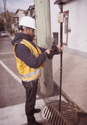
Beyond this with a survey-grade receiver such as the eos Arrow Gold, plus a subscription service such as Leica SmartNet then GNSS centimeter accuracy is achievable in Real-time! Again, why would you need this kind of accuracy? When recording the position assets that make up any gravity-reliant system such as water/wastewater then an accurate digital twin is critical for modeling the behaviour and performance and this means accurate positions recorded in 3D. In terms of re-locating assets that have been buried or grown over or flooded then accurate digital positions could mean the difference of crucial minutes when, for example, locating a submerged valve to turn off during a leak.
Using an Asset Capture system such as ArcGIS field maps with plugin technology such as the arrow will allow you to capture and locate with confidence.
Conclusions
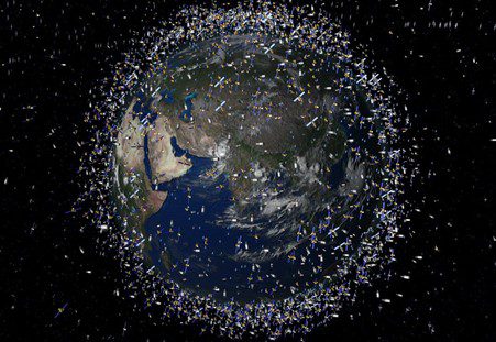
Human-made satellites are obviously growing rapidly in terms of numbers. In the coming years, SpaceX alone is planning to launch more than 40,000 to create so-called ‘mega-constellations’ in low-Earth orbit with the goal of bringing the internet to underserved parts of the globe. These sheer numbers will add to obvious problems, there are already astronomers seeing stars blocked out by satellites and certain radio frequencies are being interfered with meaning equipment sensitivity is lost. The increasing risk of collisions is causing more space debris to be created and this poses a serious risk to astronauts in the ISS and other space stations. Also, from a moral standing, there is increasing concern about remote sensing of populations giving those who control them unprecedented spying powers and the further erosion of privacy.
Putting these points aside, in general satellites have been a major force for good with humanity. They have helped us to navigate, communicate, be alerted of natural disasters, increase our food production, improve our infrastructure, and on a grander scale learn about the history of the universe and the future of humanity and the Earth. Earth’s satellites are ultimately here to stay!
About
With degrees in Geological Sciences and Geographical Information Systems, Darius has significant expertise and knowledge of Geospatial tech integration, specialising in high-accuracy mobile GIS deployment. Darius is the technical lead for IPAS and supports other large GIS-centric contracts in the utilities sector. Combining GIS development skills and years of customer insight he was able to create some of our leading solutions Z-Transform and DDMS for Highways.


