CASE STUDY
Sustainable conservation: Reducing risk for Northumbrian Water Group’s Asset Management
Our location 53.38538, -2.97972
Sustainable conservation: Reducing risk for Northumbrian Water Group’s Asset Management
Northumbrian Water Limited (Northumbrian Water) (NWG) provides water and wastewater services to the North East of England and water services in the South East, where it operates as Essex & Suffolk Water.
Helen Jacobs is the senior conservation advisor at Essex & Suffolk Water, and part of her team’s role is to manage tree safety across Northumbrian Water and Essex & Suffolk Water estates, and so their approach to tree safety has evolved over the years, as has best practice.
Helen and her colleagues at Northumbrian Water were managing the safety of the trees on their treatment works near neighbouring properties, footpaths and roads. “We were managing it using excel spreadsheets and it became clear that it wasn’t robust enough for our needs and that’s where this Tree Management System project started.” Helen explains, “There was a need to look at the whole process; the admin, the data collection, the audit side of it, as well, because when you are managing safety issues it’s important that you have a robust process. We wanted to have more confidence in the system because it is a critical thing.”
The System would allow Helen and her team to capture trees geospatially; to see where trees are on a digital map, to schedule maintenance and to keep an eye on the status of works – therefore being able to manage the whole process at a high level. “What we really wanted was to manage it in a more time-efficient and therefore cost-efficient way and in fact managing tree safety is a spatial process. It was a spatial problem that we were wrestling with, so to be able to see that mapped digitally was just so obviously going to make the process flow better, and it was going to be easier to get at the information we needed once we could input and store information in a spatial way. So that’s why MGISS came in with their expertise.”
“The tree management solution was a solution to bring a business process into the digital age.” Andy Hopkins is a GIS architect at Northumbrian Water, and explains why it was vital for NWG to adopt this new system. “We couldn’t find anything, we didn’t know where things were, for a start. Seeing it on a map kind of brings it to life.”
Working closely with the conservation team to address their pain points, MGISS went through the whole process of defining the problem, what data comes in, what does that data look like. There was also a vital period of tweaking and testing in order to determine that the conservation team could get the best out of the system.
Helen can already see a difference with using the new system, “Now we can interrogate the data so much quicker, we’ve got rid of a lot of potential user error – because myself and my colleagues were inputting the data manually, trying to manipulate spreadsheets and manually getting a report and then painstakingly moving it into an excel document and then having to create sometimes a pen and paper map to tell the field operator where the trees were.”
Helen explains how happy she is to no longer spend all of her time in excel and creating manual maps, “I’ve got it all there. I feel so much more confident now because everything’s there and it can flag and I can easily run reports if something’s overdue, and we’ve got all those things we asked for – more robust, more reliable, a slicker process, less staff time, more easily auditable. Now, rather than having to rely on someone to remember or to check or to run the right integration on an excel spreadsheet, instead it’s there, it’s built into the process.”
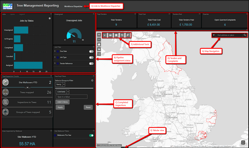
“For me personally it was very helpful to have the training that mgiss did with us, and then I was involved with the ongoing development to make sure the process was how we needed it. Adapting to a new system has been a learning process but we are getting there and what the team really love is that once they get used to using the system, how much information is then at their fingertips, all there on their phones.”
“Showing where the trees are emphasises what we’re trying to do as a business, that location matters. We’ve worked with MGISS before, so they understand our business requirements, they de-mystify the technology for us, they understand where we should be going and advise us.” Andy highlights how important the good working relationship between the two organisations has been to the success of the project, and for NWG as a whole, “They’re really key to us because the geospatial industry is so fast moving, and we’ve got to keep on top of it, and to do that we need experts around in times of business need. Having that base data-set, that we can share openly within the business and perhaps even externally going forward – that’ll be the legacy.”
“So now with this tree management system it’s definitely a massive improvement, and as we use it more and more we’ll see what more we can do to evolve it – we’ve already seen how this technology can definitely help us in other parts of our work, which has been really eye opening for us.” Helen adds, “The work I do in conservation; in managing woodlands, managing habitat, grasslands, wetlands – it’s all spatial and all of it could benefit massively from having this kind of visualisation in the GIS System, so it looks like it’ll be something I’ll be involved in more!”


